Showing posts with label flooding. Show all posts

Monday, October 7, 2013

County Route 49, Winthrop New York - Part 2

I was making a driving tour of a short section of County Route 49 (see yesterday's post). It was a beautiful drive through the scenic rural landscape:

Although this was generally very flat land, I noticed that many homes were set up atop small rises and wondered if that was for better views or because of the nearby St. Regis River:

This was only a mile or so out of the village of Winthrop, not far from either Massena or Potsdam. I imagined that the local residents were folks who worked in town but loved rural living:

This home had a wonderful front porch on which I'd once seen a group of woman enjoying a sultry summer afternoon in the shade of those trees:

Besides farm land, there were patches of forest:

A home with a flag and double garage:

Another home with a double garage, but also a three stall, free standing garage:

RJ Firearms, probably a busy place in hunting season:

A carport and a little bridge for when the drainage ditch gushes with rainwater. But in spite of the big rainstorms the previous night, it contained no water when I passed by:

Just before I turned off onto the state highway, I stopped to snap a photo of this well cared for home with its classic red barn. Though it is faster to stay on the state road, I often will detour by way of the county road just for the scenery:

Sunday, October 6, 2013

County Route 49, Winthrop New York - Part 1

First, before we begin - Please notice the new "Click Here For Farm Website" button. It will take you (in the same window, so you should wait until you're done with today's post) to the brand new Windswept Farm Red Poll Cattle website. So what if I don't actually have the cattle yet? So what if the pictures, though mine, were taken on other people's farms? Hey, a guy's got to start somewhere.

St. Lawrence County Route 49 is a long and busy road as country roads go, but there is a short section which runs parallel to the state highway which only locals generally use. I decided it would be a great place for a driving tour:

Located on the St. Regis River, this house had great collections of all kinds of things and, apparently, even more stuff behind those fences made of old roofing:

There were many mobile homes, inspiring me to think they were probably the sons and daughters of the prior generation's farmers:

I noticed that nearly everything had sloped roofs. This is, after all, big snow country:

This attractive home showed evidence of the previous night's big rains (see yesterday's post):

This big, modern house sat far off the road:

I couldn't tell if this barn was brand new or an older barn which had been extensively renovated. I liked it a lot:

This classic farm house sat up on a rise where it had some views:

Another mobile home to which a sloped roof had been added:

And another trailer, this one nearly hidden behind a row of Eastern White Cedars:

The seemingly ever present St. Regis River made an appearance as it turned away from the road and off into the forest. But there was still more to see on this short section of County Route 49 and I'll post Part 2 tomorrow:

Saturday, October 5, 2013

After The Storm

On a Wednesday evening I noticed with alarm that all TV programs were being interrupted with weather alerts warning of violent storms approaching. They listed many of the closest settlements to me as the epicenter. Indeed, when the rainstorms arrived, it felt like we were in a battle zone, with lightning strikes so close that the house shook. It poured rain all night long. The next morning, I saw wet, sodden, muddy fields everywhere:

There is usually no pond here, but rather a local man's carefully groomed lawn:

Hay fields were surrounded by what looked like moats:

The local creek had risen over its banks:

The ditch in my neighbors' pasture had become a torrent:

The ditch along the road and across from my house had filled and was backing up. The culverts could not carry water fast enough:

And at the other end of those culverts, water spewed out under great pressure:

Tractors and other equipment had been left in the fields:

The ground was so wet that I guessed they wouldn't try to move their tractors until it dried out lest they tear up the soil:

All along the roads were flooded sections which brought field work to a stop:

The poor corn fields had been flooded through a good part of June, and now they were flooded again. Smaller farmers, who couldn't afford extensive drainage systems in their fields, seemed to be having a very rough year for corn:

The St. Regis River had widened considerably and, in spite of its calm look, was rushing headlong toward the St. Lawrence. I left my own tractor parked in the barn and began waiting for things to dry out:

Thursday, January 26, 2012

Hiking Vroman's Nose, Part 2

I could tell that we were getting near the top of Vroman's Nose, but there hadn't been any scenic overlooks so far. But Clover and Daphne dashed about through the forest and the oak leaves like two little woodland elves. They were having a magnificent time:

Daphne runs up to me every few minutes to look up and see if she can get me to be more fun - and also to be sure I'm still happy with everything:

We were withing a few feet of a cliff and I was wondering if I'd better put the dogs on their leashes:

Aack!!! I quickly put the dogs on their leashes:

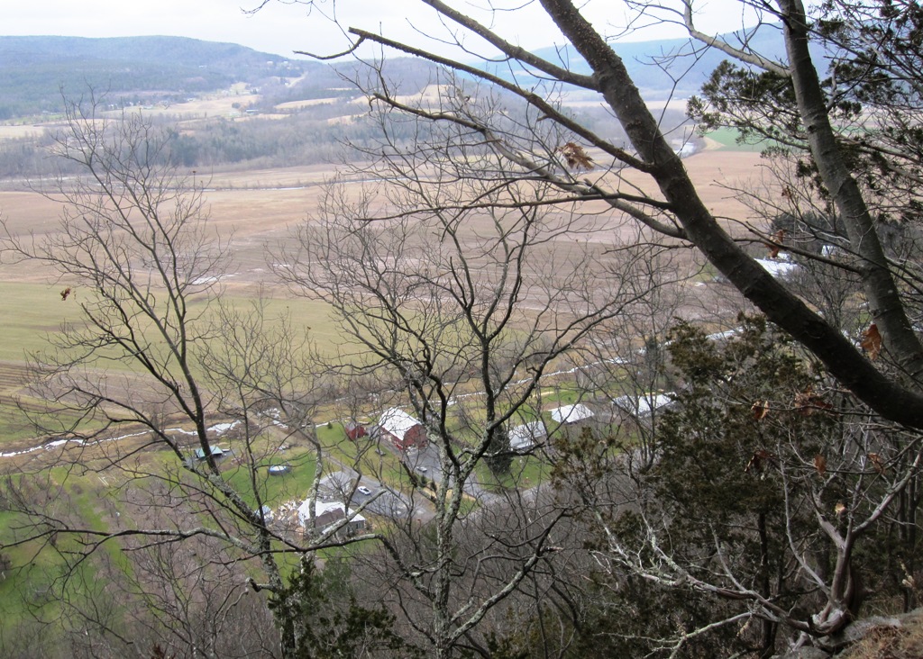
From this, the first of many scenic overlooks, I could see out over the Schoharie Valley to the mountains beyond:

Looking at the farms and barns in the Schoharie Valley below felt as if I was in an airplane looking down:

But wait, there's more! We continued to climb up to the next rocky crag where I felt sure there'd be more views:

And indeed there were - farm fields neatly squared and trimmed, with mountains just behind them:

That river is Schoharie Creek, not very impressive most of the year but a flooding, raging torrent many times in the spring melt. It's the Schoharie Creek which took down two bridge spans of the New York Thruway and just this past August took down a covered bridge after Tropical Storm Irene:

But the scene on that day was all pastoral loveliness and calmness, at least as long as I had the dogs on their leashes. But we weren't to the top yet. I'll post more tomorrow:

Sunday, May 15, 2011

Tupper Lake Was Flooded And Bog River Was Raging

The dogs and I were traveling south toward Albany and hoping we wouldn't be stopped by any of the flooding which had closed so many roads in the Adirondacks. I had to take one minor detour as we entered the town of Tupper Lake, but after that the drive went well. In the southern part of the town, however, the houses along the shore of Tupper Lake were seriously flooded:

Beautiful shoreline houses were inundated with water:

Children must have lived in this house because their playground toys were flooded:

This house was so far off in the flooded area that I suppose it could only be reached by boat:

But a casual glance across the main part of Tupper Lake appeared as calm and lovely as ever:

We traveled south of the town, the highway still following the shoreline of Tupper Lake. I saw a small side road to a picnic area and took it just to investigate. An old stone bridge crossed the Bog River where it flowed into Tupper Lake and it was a raging torrent:

I parked near the bridge and walked to the center of it to video the flooded, dangerous Bog River. I confess that I was a bit worried that even that massive stone bridge might be taken down by the swollen river:


When I was done, I walked back to where the dogs anxiously waited:

But then I noticed that I could easily walk right down to the raging river:

The river was so hugely flooded and rushing at such terrifying speed that I was afraid to get too close. A simple misstep would mean I'd be gone instantly and likely never found:

Here's a video of the Bog River flowing under the bridge and into Tupper Lake: