Showing posts with label Mount Greylock. Show all posts

Friday, March 2, 2012

Part 2 - The Fire Tower On Beebe Hill

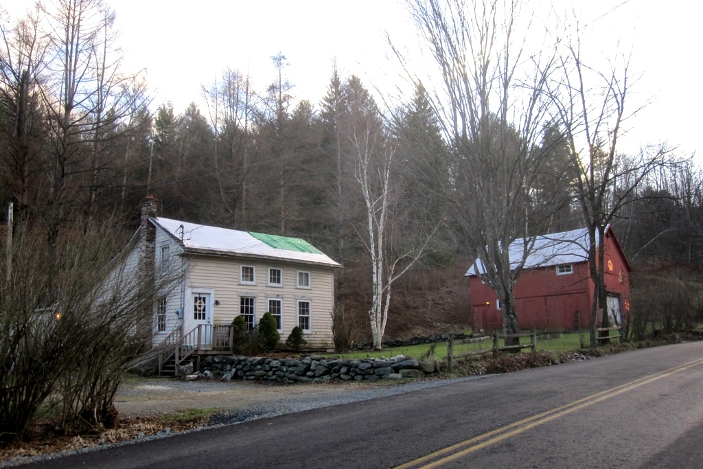
The hike up Beebe Hill to the fire tower was quite brief, less than 1.5 miles, and it wasn't long before I spotted the caretaker's cabin up ahead with the fire tower itself rising up behind it:

A man with two little girls and a small dog arrived at the same time we did. He told me that he hadn't brought a leash for his dog and didn't want her interacting with mine, so I said I'd wait by the caretaker's cabin while he and his girls went on ahead to the fire tower. While I was waiting with my dogs on a leash, a friendly family of six adults arrived to explore the tower for themselves:

I tied Seamus and Fergus at the bottom of the fire tower:

And Clover and Daphne to the other side. I didn't want any of them attempting to follow me up those steps:

And then I began ascending the fire tower. As I climbed, the caretaker's cabin began to look smaller and smaller down below. The Taconic Mountains formed an attractive backdrop:

One couple did not want to climb the tower, so they waited on the ground for the rest of their party, by now at the top of the fire tower. My dogs were barking for attention and by time I arrived back down on ground level, this couple had made friends with all four dogs:

And the view from the top was superb, clearer than I'd ever seen it before. I could clearly see the windmills atop Brodie Mountain and Mount Greylock in the Berkshires of Massachusetts. Alas, the photo doesn't show enough detail to be of much help, but even my aging eyes were able to clearly see the windmills' details. I couldn't, however, make out the tower atop Mount Greylock:

The towers of the Empire State Plaza in Albany rose up above the trees like the city of Oz in the distance, about 40 miles away:

I enlarged and cropped the above photo to help illustrate what I so clearly saw on that sunny afternoon. Because most of Albany's downtown sits down in a valley, only the Empire State Plaza (and sometimes the State University towers) are usually visible from mountaintops. Can't you just imagine Dorothy, Toto and friends following the yellow brick road toward that city in the distance?:

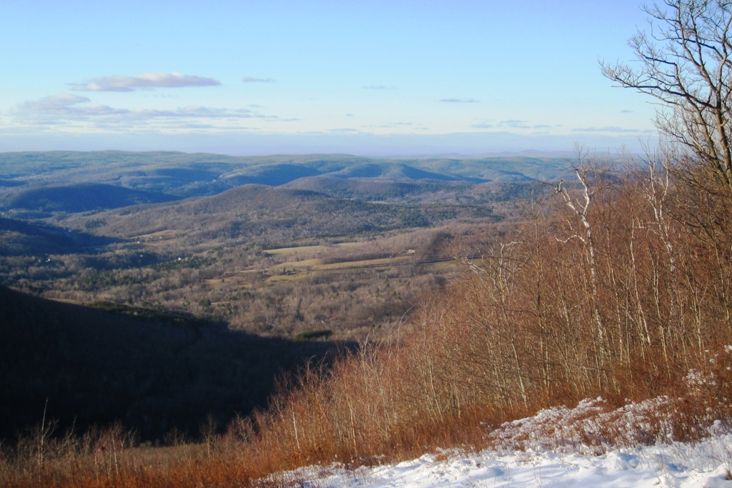
And the rolling hills of the Hudson Valley stretched out below us in another direction:

Seamus and Fergus looked quite tiny down on the ground below:

I had a nice conversation about hiking with a man from Pittsfield, Massachusetts as we stood at the top of the fire tower enjoying the view. But it was windy and my dogs were anxious, so I began to descend the stairs to continue the hike back to the trail head:

Friday, January 6, 2012

Finishing Our Hike On The Taconic Crest Trail

We were on our way back to the trail head and my parked car. It had certainly not been a difficult hike, perhaps only 5.5 miles and mostly level, but my legs felt like rubber. I knew this muscle weakness was a bad side effect of a drug my doctor'd had me try. I would certainly stop taking it, but for now I just needed to make it back to the car:

Though I was feeling increasingly weak and tired, the four pooches were having themselves a merry old time, When they'd run too far ahead, I'd just call them back to me and they'd come running with enormous enthusiasm. A little petting and praise works wonders:

Being late December, the sun set very early and we were mostly walking right towards it. The setting sun and slanting sunshine gave everything a magical appearance:

I knew that just before the trail head was a scenic overlook not too far from the path. I gave a call for the dogs and walked over there, tired legs and all:

This view looked out over the Taconic Valley and the towns of Petersburgh and Berlin. Of course I couldn't see that far, but Albany also lay off in that direction:

Route 2 runs up the valley between where we stood and that next mountain. My car was parked at the foot of that mountain. I heard no more laughter so assumed the sledding children had all gone home:

Farm fields cut out of the forest down in the valley:

But the lengthening shadows and my very weak legs gave me good reason to continue on toward the car:

I put the dogs all on leashes in order to cross the highway. I then loaded them up into the car and snapped one last photo of Massachusetts' Mount Greylock not too far away:

The dogs were not at all tired. They'd have loved to hike some more but I wanted to go home:

One last glance across the road to the start of the trail we'd just hiked and I began driving home:

And on the way stopped for a quick photo of the house I used to own, in which I lived when I adopted my two boys. The hayloft of that barn is where I lived for three years before that. It brought back lots of memories, some good and some bad. But it was time to drive home and take a rest:

Thursday, January 5, 2012

Lengthening Shadows On The Taconic Crest Trail

The dogs and I passed over the peak which had been almost clear-cut and continued on toward the Snow Hole. I knew from previous hikes that a very nice overlook was just ahead and planned to stop there. We rested at that scenic place and enjoyed the view. This is looking southwest with the towns of Petersburgh and Berlin in the valley below:

And Seamus also enjoyed the uphill view:

Looking toward the southeast, we could see Route 2 winding its way up across Petersburgh Pass where we had parked to begin our hike. The wind had blown snow onto the bushes where it stuck in clumps and looked like frozen cotton balls:

Clover and Seamus watched me as I moved around snapping pictures. They must have been wondering what on earth I was doing:

But I was tired and it was already afternoon. So we began the return trip, following the same trail by which we'd come. The two Papillons led the way:

It was only mid-afternoon at that point, but the shadows had already begun to lengthen and I could feel the evening chill spreading across the landscape. My legs were weak, a bad side effect from a new drug the doctor had me try. It became so problematic that I began to worry about making it back to the car. I did make it, though, and have since called the doctor and discontinued that medication:

We passed back over the peak where all the trees had been cut down:

At one point I could see Mount Greylock in Massachusetts directly ahead of us. I could easily see the War Memorial Tower at its peak although you probably can't see it in the photo:

My camera's self-timer hasn't been working but I got the idea to just hold it at arm's length and snap my own picture. The result was this scary image. Is it a snow monster?:

I marvel that these little Papillons never seem to get cold. They may be small, but they are surely athletic dogs, a go anywhere, do anything breed if there ever was one:

Daphne and Fergus pose in the afternoon shadows:

On and on we walked, the dogs having a grand old time and me with weakened, wobbly legs. But I'll post more tomorrow from our Taconic Crest Hike:

Sunday, January 1, 2012

Beginning A Hike On The Taconic Crest Trail

I'd attempted to hike the Taconic Crest Trail (AKA the Snow Hole Trail) on Christmas day but arrived at the parking area only to discover that I'd dressed quite imprudently for the high altitude weather and had forgotten my camera. So I returned the very next day, better prepared, and happily discovered a warmer day. I drove east on Route 2 through Rensselaer County until I passed through the tiny town of Petersburgh, New York. I could see the Taconic Crest straight ahead of me. That's where I'd be hiking, from right to left as it shows in this photo. You can see Route 2 winding its way up and over the mountains on the right hand side just below some telephone wires:

I parked in the parking lot at Petersburgh Pass, the highest point on Route 2, just a stone's throw from the Massachusetts border and pretty close to Vermont also. There once was a ski resort here, but now it's just a parking lot for hikers and outdoor enthusiasts. There were many people using the old ski slopes for sledding on that day. They sure were having fun:

From where I parked I could see Mount Greylock, the highest mountain in Massachusetts. You can see the War Memorial Tower at its peak if you click the photo to enlarge:

The dogs and I crossed the highway (there's very little traffic) and climbed up that steep slope to begin our hike:

The first several hundred feet are rather steep, but it's actually a rather easy hike after that. The dogs were all excited and running in circles:

When we reached the top I looked back at the people sledding on the other side. I could hear the children's laughter clear across the valley:

I signed the trail register and began the hike. All the sounds became muffled and a sense of serenity and peace  enveloped us as we entered the forest. Even the dogs seemed to sense it:

With all the leaves off the trees I could see mountains in every direction. Notice Fergus' ears flopping as he joyously romps along the trail:

Everything was snow covered but neither slippery nor deep. It was just right - except, that is, for the howling winds:

On and on we hiked through Hopkins Memorial Forest, now owned by Williams College in Williamstown, Massachusetts:

The trees are never very tall or old looking and I suspect that is a result of their rugged, mountaintop environment. But the forest is stunning nonetheless:

There were so many trail markers as to be almost silly. At times they seemed almost to be defacing the forest because there were so many of them. But I figured that too many was better than too few, especially for wintertime hikers. But we were just getting started. I'll post more tomorrow:

Sunday, August 14, 2011

Bascom Lodge On Mount Greylock

Having explored the summit of Mount Greylock on foot and climbed the War Memorial Tower, I was ready to walk over to Bascom Lodge to revive more pleasant memories:

This beautiful, rustic lodge was built of native stone and lumber, procured mostly from the clearing of hiking trails. It opened in 1937 to skiers, hikers and sunrise-seekers:

I entered the front door and encountered this lovely rustic sitting room:

This is not a deluxe hotel but rather a rustic inn, a pleasant night in a real bed for many hikers of the Appalachian Trail:

Each day Bascom lodge serves homemade meals made from local ingredients grown without pesticides and shipped without preservatives. They were serving until 4:00 but I'd already eaten so I just snapped a picture and continued on my way:

I walked onto the back porch with its gorgeous views of the surrounding Berkshire Mountains. Alas, the moose head which used to hang on the wall was no longer there:

Off limits to non-paying guests, the stairs lead upstairs to the rooms which can be rented. In days past I've broken the rules and sneaked a peak. I found them to be barracks type rooms whose main purpose is to allow Appalachian Trail hikers a respite from the hard, stony ground:

One more glance back as I exited the Lodge:

Directly outside the front door is this amazing scene:

A young couple was walking down the hill through the field of wildflowers on their way to Bascom Lodge. But it was time for me to head home so I walked back to my car and began the journey: